
|
SHASSA
The Southern H-Alpha Sky Survey Atlas
Arcminute-Resolution Digital Images of Interstellar H-alpha
Emission
John E. Gaustad (1938-2025)
(Swarthmore College, emeritus)
Peter R. McCullough
(University of Illinois)
Wayne Rosing
(Las Cumbres Observatory)
Dave Van Buren
(Extrasolar Research Corporation)
|
 |
This page is dedicated to the work and memory of John Gaustad, 1938-2025. If you have questions about the survey, please contact Eric Jensen.
SHASSA is now included in NASA's
Skyview Virtual Observatory.
Introduction
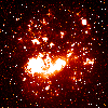
The Southern H-Alpha Sky Survey Atlas is the product of a wide-angle digital imaging
survey of the H-alpha emission from the warm ionized interstellar gas of our Galaxy.
(Details of the survey are contained in the accompanying
paper.)
This atlas covers the southern hemisphere sky (declinations less than +15 degrees).
The observations were taken with a
robotic camera operating at Cerro Tololo Inter-American
Observatory (CTIO) in Chile. A similar survey (VTSS) of the northern hemisphere sky is being carried out at the Virginia Polytechnic
Institute. (The WHAM survey also covers the northern hemisphere, but at higher sensitivity and lower angular resolution.) At low galactic latitudes, these images show the structure of the diffuse,
warm, ionized component of the interstellar medium. It is hoped that their study
will lead to a better understanding of the dynamics and evolutionary history of
the interstellar gas. At high galactic latitudes, where little or no H-alpha emission
is seen, the images are still scientifically useful. The intensity of the free-free
emission from Galactic hydrogen is directly proportional to the brightness at
H-alpha, so careful analysis of these images should reveal any anisotropies in
the Galactic free-free emission at microwave wavelengths (or proof that these
are negligible), emission which must be subtracted from satellite or ground-based
measurements to obtain the true cosmic background fluctuations. Survey images
are available for downloading from this site. The images are in FITS format (Flexible Image
Transport System). If you use any images for research or other purposes, we request
that you use this acknowledgement.
Sky Coverage and Image Specifications
The atlas consists of 2168 images covering 542 fields
south of +15o declination.
There are four images available for each field: H-alpha, Continuum,
Continuum-Corrected (the difference of the H-alpha and Continuum images),
and Smoothed (median filtered to 5 pixel, or 4.0 arcminute, resolution
to remove star residuals better).
The images have the following specifications:
- Each digital image is a rectangle, 1014 x 998 pixels, approximately 13o
on a side.
- Pixels are 0.8 arcminutes in width.
- The sensitivity in an H-alpha image is about 0.5 rayleigh
(1 R = 106/4pi photons cm-2 s-1 ster-1,
corresponding to an emission measure of about 2 cm-6pc).
The fields are labeled with a field number.
Field numbers 002-269 have the same
centers as the correspondingly numbered fields in the IRAS Sky Survey Atlas
(ISSA).
Field numbers 502-769 are displaced from the above centers by +5o
in RA and -5o in Dec.
Fields 435-437 and 935-937 cover the South Polar region.
Download Images
The coordinates for field centers provided in the following lists and image
maps are approximate. (An accurate coordinate specification is included in
the FITS file header for each image).
The images are provided in compressed (gzip) form. If you cannot
decompress the files, and you wish access to them in uncompressed form,
please contact us via the form below.
If you use any images for research or
other purposes, we request that you
use this acknowledgement.
You may download images from a:
or search for the correct field for a specific position of
interest:
Users wishing to download a large number of images may find
it more convenient to do so via the anonymous ftp server
amundsen.swarthmore.edu/SHASSA/ or the alternative server
ftp.lco.org/SHASSA/.
The full Atlas can also be obtained as a set of three CD-ROMs.
Contact Wayne Rosing
(wrosing@lco.org) for details.
Mosaic Map
The following clickable mosaic map (in galactic coordinates) can be used to
find images corresponding to features seen.
Click on any point within the mosiac to display the image which has
its center
nearest that point.
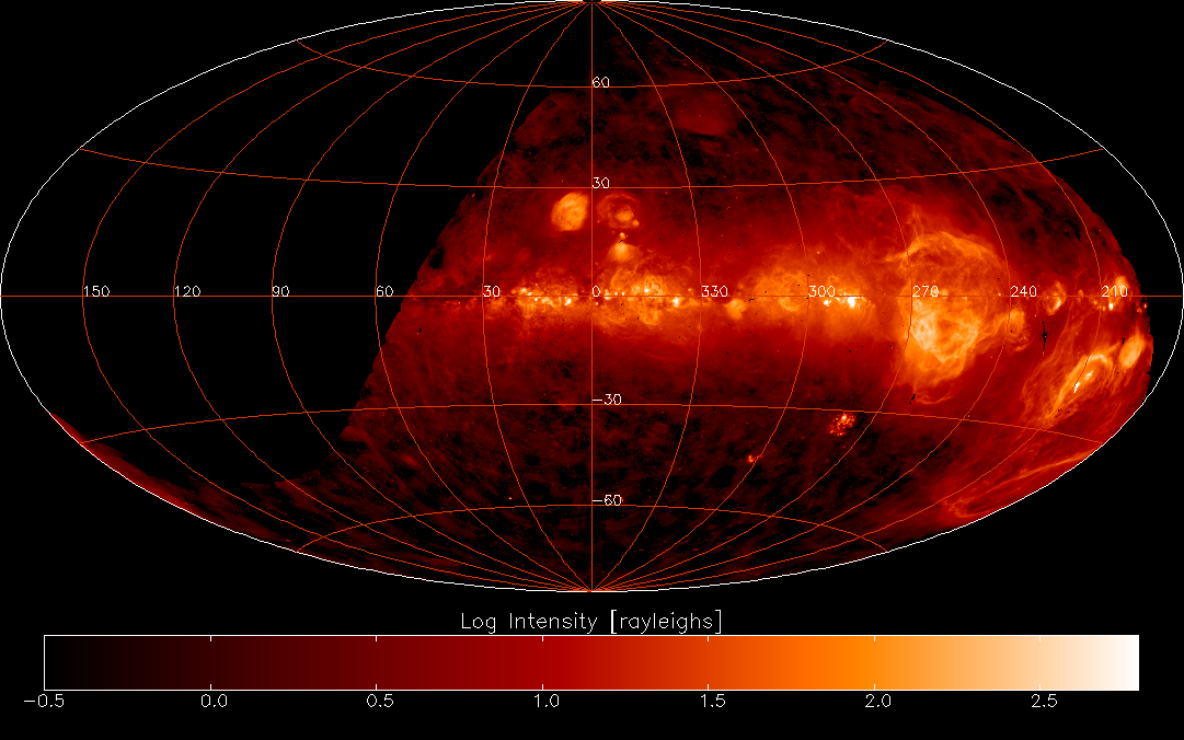
A GIF image containing the above map may be downloaded by clicking
here
with your right mouse button
and then selecting "Save Link As..." or "Save Target As..." depending on your browser.
Versions of this mosaic map in FITS format (on a linear scale and without grid lines)
can be obtained by clicking here.
An all-sky map based on SHASSA, WHAM and VTSS data has been constructed by D. Finkbeiner.
Personnel
|
People who have worked on this project include:
|
| Senior Personnel |
Junior Personnel |
Graduate Students |
Undergraduate Students |
- John Gaustad
- Peter McCullough
- Wayne Rosing
- Dave Van Buren
|
|
- Ray Chen
- Patrick Hentges
- Ian O'Dwyer
|
- Peter Austin
- Chad Bender
- Nat Farney
- Katherine Hall
- Nini Khowrowshahi
- Dan Logan
- Eun Oh
- Jim Pulokas
- Lynne Raschke
- Brett Schnieder
- Dan Seaton
- Yuhki Tajima
- Anteneh Tesfaye
- Andrew Voellmy
|
Publications
-
"A Robotic Wide-Angle H-alpha Survey of the Southern Sky"
by J.E. Gaustad, P.R. McCullough, W. Rosing, and D. Van Buren
2001, PASP, 113, 1326
This paper may be downloaded from NASA/ADS
here.
- "Imaging the Entire Southern Sky in H-Alpha"
by P.R. McCullough, J.E. Gaustad, W. Rosing, and D. Van Buren 2001,
in Tetons 4: Galactic Structure, Stars and the Interstellar Medium,
(ASP Conference Series, San Francisco), 231, 366
- "A Robotic Wide-Angle H-Alpha Survey of the Southern Sky"
by J.E. Gaustad, W. Rosing, P.R. McCullough, and D. Van Buren 2001,
in Small Telescope Astronomy on Global Scales, IAU Colloquium 183,
(ASP Conference Series, San Francisco), 246, 75
- "A Robotic Wide-Angle H-Alpha Survey of the Southern Sky"
by J.E. Gaustad, W. Rosing, P. McCullough, and D. Van Buren 2001,
in Astronomy in Ukraine-2000 and Beyond (Impact of International Cooperation),
ed. Ya. S. Yatskiv, Kinematics and Physics of Celestial Bodies Suppl Ser., 2000, N3, 136
- "The 5o Diameter Ionized Halo of the Planetary Nebula Abell 36"
by P.R. McCullough, C. Bender, J.E. Gaustad, W. Rosing, and D. Van Buren 2001,
ApJ, 121, 1578
- "The Southern H-Alpha Survey: An Amateur-Professional Collaboration"
by J.E. Gaustad, W. Rosing, P.R. McCullough, and D. Van Buren 2000, in
Amateur-Professional Partnerships in Astronomical Education and Research,
(ASP Conference Series, San Francisco), 220, 169
- "A Wide-Angle H-alpha Image of the LMC"
by J.E. Gaustad, W. Rosing, P.R. McCullough, and D. Van Buren 1999,
in New Views of the Magellanic Clouds, IAU Symposium 190, 99
- "Quantifying Brightnesses and Radii of Known Objects Observed with the H-Alpha Southern Sky Survey", by K.J. Hall 1999, Senior Thesis, (Dept. of Physics
and Astronomy, Swarthmore College, Swarthmore PA)
- "Implications of H-Alpha Observations for Studies of the Cosmic Microwave Background"
by P.R. McCullough, J.E. Gaustad, W. Rosing, and D. Van Buren 1999, in the
Sloan Summit on Microwave Foregrounds, (ASP
Conference Series, San Francisco), 181, 253
Registration/Feedback
If you are a casual visitor to this web site, welcome!
If you are an astronomer and wish to receive
notification of corrections or updates to the Atlas, or
have comments or questions about the survey, please fill out the following form:
or send email directly to
Eric Jensen at Swarthmore College
(ejensen1@swarthmore.edu). (John Gaustad, the originator of this survey, passed away in November 2024. For the time being, it will remain available here, and questions can be directed to Dr. Jensen.)
This work has been supported by National Science
Foundation grants AST-9529057, AST-9900622, and AST-9874670,
by NASA Contract NAS7-1260, and by Las
Cumbres Observatory, Dudley Observatory, the Fund for Astrophysical Research,
Research Corporation, the University of Illinois, and Swarthmore College.
Any opinions, findings, conclusions or recommendations expressed in this material are those of the authors and do not necessarily reflect the views of the National Science Foundation or of any of the other organizations listed above.
The observations were obtained at Cerro Tololo Inter-American Observatory,
which is operated by the Association of Universities for Research in
Astronomy, Inc., under cooperative agreement with the National
Science Foundation.
The design of this web page was patterned after that of the Virginia Tech Spectral-Line Survey (VTSS).
SHASSA | Swarthmore
Astronomy| Swarthmore Physics and
Astronomy | Swarthmore College